Vavilov Centers or Vavilov Cultures? Evidence for the Law of Homologous Series in World System Evolution
скачать Автор: Plachetka, Uwe Christian - подписаться на статьи автора
Журнал: Social Evolution & History. Volume 19, Number 2 / September 2020 - подписаться на статьи журнала
DOI: https://doi.org/10.30884/seh/2020.02.07
In this paper Vavilov centers, which are crop biodiversity hotspots, are considered as agricultural areas of original crop evolution and crop diversity and therefore as pristine information-based World Systems. The relevant information is the DNA of the cultivars. Therefore, the concept of Vavilov cultures is presented here to identify some enabling and constraining conditions of the developments of regional socio-economic systems. These conditions are considered as the regime, such evolutionary processes are subject to. This issue is not clear to the eyes. The conceptual application of Vavilov's law of homologous series to socio-ecological evolution holds true for Vavilov cultures.
Keywords: Vavilov, Word-System analysis, Neolithic revolution, agricultural anthropology.
Uwe Christian Plachetka, Institute of Risk Research – University of Vienna more
1. INTRODUCTION: THE NEOLITHIC WORLD SYSTEM HYPOTHESIS
In this paper we will employ the World System paradigm as an approach to explain the socio-ecologic evolution of Vavilov centers. They are the areas of the Neolithic Revolution, where the development of cultivated plants (crop evolution) and domesticated animals started first. According to Zinkina, Ilyin and Korotayev (2017), Old World pristine Vavilov centers emerged before the so-called ‘Urban Revolution’. In this paper we will describe a ‘Vavilov center’ in terms of an agricultural area of pristine crop evolution and diversity. This term derived from the established concept of cultural areas refers to the property of Vavilov centers as socio-ecological systems (SES). Therefore, the term ‘Vavilov cultures’ is preferred. The correct term is ‘agricultural areas of original crop evolution and crop diversity.’ This is a very long term. Specific enabling and constraining boundary conditions will produce similar cultural traits. In this paper we will discuss such boundary conditions.
1.1. Vavilov Centers as Pristine World Systems?
Nikolai Ivanovich Vavilov (2004 [1931], 1951) was the first to identify the gene-pools that is the genetic relatives of modern cultivars (Khoury, Achicanoy et al. 2016) based on his law of homologous series (Vavilov 1922) for their improvement. These wild and weedy genetic relatives are capable for hybridizing the few staple cultivars that feed the world in terms of calorie intake (Schmidt and Wei 2006). Vavilov developed his taxonomic-geographic approach to identify the regions of crop diversity on a World Map. Such a representation motivated the term ‘Vavilov centers’. In this paper we do not focus on the genetic issue. The focus lies on Zinkina, Ilyin and Korotayev (2017). They consider pristine World Systems as by-product of pristine Vavilov centers as manifestation of early stages of World Systems. Vavilov had a similar hidden agenda beyond the realm of plant breeding.
… The paradigm of historical materialism reveals that historical questions [concerning the origin of agriculture] are … of great importance for modern agriculture. In contrast to the previous practice, the present researcher … tries to use the experience of the past in order to improve today's practice. In the Soviet Union, … the problem of the origin of agriculture, of cultivated plants and of the domestication of animals interests us mainly from a dynamic point of view (italics in the original – U.C.P.). Knowing the past, studying the elements from which agriculture has developed, collecting plants grown in the old agricultural centers, we have tried to dominate the historical process [also known as the momenta of crop evolution, – U.C.P.]. … In short, the historical problems of the origin of agriculture, … are of special interest for … our directing and controlling the reproduction [i.e. the evolutionary pathway] of cultivated plants and animals… (Vavilov 2004; translation and shortened by me – U.C.P.).
Vavilov's method is the taxonomic-geographical approach (Harlan 1971)
which means that the geographical regions of maximum intra-specific diversity
of a crop per grid square indicate the area of pristine agriculture (Fig. 1).
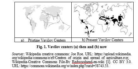
Vavilov (2004 [1931]) plotted eight primary centers clockwise. The Vavilov centers in Fig. 1b are numerated counter-clockwise. The numbers (#) will be corrected (corr. #) according to Hawkes (1997) in Table 1.
Table 1
Vavilov centers with their original numbers
|
# |
Corr. # |
Description |
|
8 |
1 |
The Chinese Center – in which he recognizes 138 distinct species of which probably the earlier and most important were cereals, buckwheat and legumes |
|
7 |
2 |
The Indian Center (including the entire subcontinent) – based originally on rice, millets and legumes, with a total of 117 species |
|
7A |
2a |
The Indo-Malayan Center (including Indonesia, Philippines, etc.) – with root crops (Dioscorea spp., Tacca, etc.) preponderant, also with fruit crops, sugarcane, spices, etc., some 55 species |
|
6 |
3 |
The Inner Asiatic Center (Tadjikistan, Uzbekistan, etc.) – with wheats, rye and many herbaceous legumes, as well as seed-sown root crops and fruits, some 42 species |
|
4 |
4 |
Asia Minor (including Transcaucasia, Iran and Turkmenistan) – with more wheats, rye, oats, seed and forage legumes, fruits, etc., some 83 species |
|
3 |
5 |
The Mediterranean Center – of more limited importance than the others to the east, but including wheats, barleys, forage plants, vegetables and fruits – especially also spices and ethereal oil plants, some 84 species |
|
5 |
6 |
The Abyssinian (now Ethiopian) Center – of lesser importance, mostly a refuge of crops from other regions, especially wheats and barleys, local grains, spices, etc., some 38 species |
Table 2 (continued)
|
# |
Corr. # |
Description |
|
1 |
7 |
The South Mexican and Central American Center – important for maize, Phaseolus and Cucurbitaceous species, with spices, fruits and fiber plants, some 49 species |
|
2 |
8 |
South America Andes region (Bolivia, Peru, Ecuador) – important for potatoes, other root crops, grain crops of the Andes, vegetables, spices and fruits, as well as drugs (cocaine, quinine, tobacco, etc.), some 45 species [including solanum tuberosum spp. andigenum] |
|
2a |
8a |
The Chilean Center – only four species – outside the main area of crop domestication, and one of these ([Solanum] tuberosum) derived from the Andean center in any case. This could hardly be compared with the eight main centers |
|
2b |
8b |
Brazilian-Paraguayan Center – again outside the main centers with only 13 species, though Manihot (cassava) and Arachis (peanut) are of considerable importance; others such as pineapple, Hevea rubber, Theobroma cacao were probably domesticated much later |
Source: copied from Hawkes 1997.
Some of the agricultural areas of original crop evolution and diversity have a considerable spatial extension. They are situated in mountain areas. Harlan (1971) introduced a distinction between ‘centers’ and ‘non-centers’. These non-centers are spatial networks among micro-centers. Zinkina, Ilyin and Korotayev (2017: 70) refer to the pristine Old World Vavilov centers before the emergence of the terrestrial Silk Road networks. These terrestrial networks had been portrayed by Barisitz (2017a). In terms of World-System research, the pristine Vavilov centers are information-based World Systems. They are identified by the diffusion of cultivars (Ibid.). The Andean area (Table 1, item 2 viz. item 8) does not belong to the Old World pristine Vavilov centers. Anyway, it is a show-case for a non-centric pristine agricultural area still under indigenous stewardship. This allows empirical research on the indigenous ways to maintain original crop biodiversity. In addition to, the Andean center is likely to have never undergone the Urban Revolution: Urban agglomerations there do not have a stratigraphic profile in terms of archaeology which is independent from archaeological horizons. Therefore, the Andean showcase is relevant to support the conception of World Systems that existed before the Urban Revolution (Zinkina, Ilyin and Korotayev 2017: 79). South-East Asia (Table 1, item 7A viz. 2a) is a derived Vavilov center and a non-planetary World System with specific cultural traits where a specific urbanization and state-formation process propelled by hubs of international trade networks for sojourners and foreign settlers there (Reid, Alilunas-Rodgers 1996). The anthropogeographer Ratzel (1882–1891) considered it as a kind of periphery in terms of human ecology. Due to the fact that the population number was not as large as in the centers of Old-World civilizations, such as China or Mesopotamia (Reid 1988) it may be a periphery, although Maritime South-East Asia was at the hub of a maritime World System stretching as far as Madagascar. There is a shortage of historical evidence to support this alternative conception.
1.2. Organization of the Paper
The chief focus lies on investigations in Peru and Bolivia. Methodologically it is shaped by agricultural anthropology as the adequate approach for in situ conservation of crop genetic resources by traditional farming systems (Altieri, Merrick 1987). Darcy Ribeiro (1992) characterized the Andean Civilization as ‘pueblo testimonio,’ that is a population with traditions dating back to their autonomous civilizations before the Spanish conquest. Therefore, some wordings are not common to geneticists as these are loose translations of the wording used in indigenous Quechua peasant parlance. They talked about their traditional knowledge based on crop biodiversity. Due to the fact that ‘during the Urban revolution the world system experienced one of the most important phase transitions in history’ (Zinkina, Ilyin, Korotayev 2017: 79) we study maritime South-East Asia in the context of the maritime Silk Road. After that phase transition the Silk Road example stands for the World System. The term ‘phase transition’ is common in thermodynamics especially for vaporizing water to have feed steam for steam turbines. Here the term phase transition is associated with the budget of mechanical work a socio-ecological system can perform: Mule caravans and ships can transport by far more payload than Andean Lamas. Such circumstances are considered as part of the ‘regime’ an evolutionary process is subject to. This will be discussed in the final part of the paper.
2. DATA AND METHODOLOGY
2.1. Research in the Andean Highlands beyond 3000 m.a.s.l.
The original project employed the methodology established by Harlan (1971) that implies: (a) field trips to indigenous farmers, (b) historical studies in agriculture and crops in use, (c) genetic analysis of the crops in use and (d) archaeological excavations. Due to the available resources the study focused on (a) talks with traditional farmers, local experts and (b) review of historical documents and local publications. Such research work in Peru is done according to a specific questionnaire including such items as crop exchange, storage of potatoes after harvest, selection of the seed potatoes and zonation, which means the selection of the adequate ecological belt for each crop. Since the interviews were not done by any technical recording devices the locals considered that as a friendly talk and could check and correct the investigator's notes, because many of them can read Spanish. Technical terms were communicated in Quechua, their native language. Since I took notes in their language, they were fascinated about my writing Quechua due to the fact that Quechua literacy is considered as an issue of mistis (Mestizos) and a bearded gringo like me, writing in Quechua made them curious. Discussing with them historical documents on their past was more bountiful, as my conversation partners understood the sub-textual information of such writings. Therefore, I published the findings from the Andean highlands in a monograph including ethnohistory (Plachetka 2011) as the just-in-time paper publications (Plachetka, Pietsch 2009; Plachetka, Muñoz 2009) by the University of Huancayo press could have been edited in a better way. The abridgement is now chronologically listed (Table 2).
Table 2
Abridgement of the essentials of the Andean research
|
Year |
Activities |
Book pages |
|
2005 |
A questionnaire was established for on-farm interviews with Quechua farmers in the zone of potato cultivation, but the key expert on an approach based on system analysis of the Andean civilization was John Earls (1989). The sites visited were Cusco, the terraced sinkholes of Moray, Ollantaytampu, Pisaq and Puno on the lake of Titicaca where we had a meeting with the chief of the Casa del Corregidor, which is a culture-center, but not as splendid as the Centro Bartolomé de las Casas in Cusco, and the school for rural Aymará farmers nearby Juli |
Questionnaire: p. 135, Research chronology, p. 26
|
|
2006 |
In 2006 archaeological aspects were searched for to reconstruct the way the Andean civilization coped with the impact of the Medieval Climatic Anomaly (MCA). Stakeholder interviews with local experts were done including the indigenous experts in order to establish a timeline indicated by Lonnie Thompson's Qellcaya glacier ice cores and the lake sediment analysis of the Lake Titicaca to get the paleoclimatic context of the archaeologic Late Intermediate Period (LIP) coincidental with the MCA, the period from ca 900–1300 CE). |
pp. 157–173 |
Table 2 (continued)
|
Year |
Activities |
Book pages |
|
2006 |
The carved rocks such as Manco Capac's rock on the Island of the Sun or ‘el fuerte del Samaipata’ were visited to check whether they had a function in the context of the impact of the MCA on the Central Andean civilization. The survey study was done in Puno, and the Island of the Sun in the Lake Titicaca where the first carved rock was visited. From La Paz the survey study was considered to Cochabamba, which was a center of maize agriculture during the Inca time and then Samaipata was visited. It was a kind of frontier installation of the Inca Empire. Since the Peruvian professor of sociology Liliana Muñoz and me hit the road immediately after the end of the rainy period, we found the same water outlet, which is still in full operation on the Isla del Sol as the chief freshwater supply for the Islanders: The carved rocks were obviously rainfall collectors |
pp. 157–173 |
|
2009 |
Visiting a potato biodiversity hotspot at the border region between the Peruvian department of Junín and Huancavelica with our partner Prof. Juan Carlos Condor, who motivated new research on biodiversity and kinship systems |
pp. 133–149 |
|
2011 |
Book published |
|
The project ended with my participation at the congress on agriculture on terraces in Cusco in 2014. At a field trip led by Mouric Bueno de Mesquita I could identify the village of Taucar as an indigenous knowledge base by the criterion of locals' identifying the sunrise azimuths needed for establishing an agricultural calendar. They do not use Inca sundials; they observe the point of sunrise on the horizon, as the horizon in the Andean region is serrated due to the mountain peaks. Checking azimuths (Plachetka 2014) was done by a directional compass as the transpacific congress integrated the Quechua experts as ‘Vavilov's Neolithic scientists’ (Childe 2002 [1942]: 75). I got to know Prof. Urpi Adela Carlos Rios (then University of Michigan), an indigenous Canas woman, whose hometown is Espinar. I put a draft paper online (Plachetka 2015a) for future joint research. This method stems from agricultural anthropology. Therefore, any use of scientific terms is begged for pardon: Even scientific literature published in Spanish in Peru is addressed to agricultural engineers or ethnobotanists frequently of Quechua cultural origin. Therefore Prof. Urpi Adela Carlos Rios became a key informant.
2.2. Data and Methodology: Indonesia and the Maritime Silk Road
The maritime Silk Road in Indonesia was the objective of two field surveys in 2017 and 2018, searching the traces of China's famous Admiral Zhèng Hé and his legacy. Zhèng Hé sailed the Indian Ocean in seven epic voyages (1405 to 1433) after the turmoil of the end of the Medieval Climatic Anomaly (MCA). It was the period of the fall of the Yuan dynasty in China, the Black Death and the interruption of the Central Asian trails of the terrestrial Silk Road. The PR China portrays Zhèng Hé (Cheng Ho) as a role-model on re-establishing the Maritime Silk Road. After global turmoil in the fourteenth century CE such an idea made sense. Zhèng Hé's legacy was chiefly identified in Semarang in 2017. The capital of the Majapahit Empire is now excavated at Mojokerto. Issues of indigenous state formation in maritime South-East Asia are discussed in Day (2002) and Reid (2000). Afterwards the Venetian Fra Mauro map (Falchetta 2006; Cattaneo 2011) has been identified as a ‘smoking gun’ for scaling World Systems especially on the level of information exchange.
In 2018 we visited a ship wharf in Sulawesi near Makassar. The distinctive trait of the Bugi ethnic group is the Phinisi ship. Horridge (2015: 39) considers the Phinisi as an offspring of the Western nineteenth-century ship type Schooner realized in Sulawesi, whereas the first document on an original Indonesian ship is an engraving at the Borubudur temple in Java (Horridge 2015: 1–16). Anyway, now it is the Phinisi to provide information on autochthonous ship cargo capacity. We were aboard a modern Phinisi in Makassar. Its crew gave us information on the ship: 25 m length, max 7 m width, 3 m flotation depth, payload: 175 metric tons (Travel Diary August 22th, 2018, page 15). Speed of the vessel under Diesel engine propulsion: 10 knots (18.52 kph). Longest non-stop travel by the crew: two days and two nights. The vessel transports nearly everything it is capable to, such as rice, coffee, coconut, cement etc. including a car we have seen aboard to islands that do not have a harbor for modern ships, so that it is also an itinerant general store or greengrocer. Navigation is now done by GPS and a large nautical compass behind the steering wheel. Wind situation: from January to June – West winds prevailing, in July and August –East Winds prevailing, said to come from the South China Sea. The crew's information on easterly winds coming from the South-China Sea (which is located northwest from Sulawesi) is to be understood in the context of the Indonesian compass rose.
North is Utara. North-East is Timur Laut (East to Deep Sea, which corresponds to the Pacific when seen from Makassar). East is Timur, Southeast is Tenggara, South is Selatan, Southwest is Barat Daya (powerful West), West is Barat and North-West is Barat Laut (West to the deep sea, Laut means Sea). Such a compass rose indicates that the directions are oriented towards a geographically defined center probably at Majapahit where such an ancient compass rose is shown in the Museum. Therefore, Heine Geldern's explanation of the cosmological state is old but still valid (Heine Geldern 1942). It explains what the city center column we have seen in Yogyakarta and in Bandung is about: Wisseman-Christie (1986: 67) derives the term negara for state in Indonesia from the Sanskrit term nagara for city, here it is the center of a mandala state (Acharya 2011). Autochthonous Indonesian narratives on Indonesian history are reportedly organized along dynasties, not territorial polities in Indonesia (as e.g., Panji 2015). Indonesia was characterized by myriads of polities frequently united by dynasties forming network empires especially by their conception of the so-called mandala system. The respective units are ‘cosmological states’ (Legge 1992; Heine Geldern 1942) that were characterized by elite rivalries and the struggle for a favorable position in trade networks.
3. RESULTS
3.1. Andean Distinctive Traits of a Vavilov Culture
Harlan's show-case for such a ‘non-centric’ agricultural area is the area of the potato original intra-specific crop diversity and crop evolution, the Central Andean region. It encompasses the Andean highland area stretching in the North-South direction from the Equator to approx. 30° Southern Latitude. The Andean mountain range is characterized by an extraordinary level of habitat biodiversity classified by specific altitudinal belts: The standard data on them provided by Pulgar Vidal (1996) had been summarized by Plachetka (2011: 31), which should be considered as an agricultural stratification along an altitudinal transect. The term ‘Ecological storeys’ (pisos ecologicos) introduced by Murra 2008 [1972], 1996) concerns the cultivated land around a settlement. Now the cordillera is focused upon: On the western escarpment of the cordillera these are Chala, Yunga, Quechua, Suni, Puna, and Jalca (the region of glaciers). The Eastern escarpment has the same ecological zonation with the exception of Rupa Rupa (upland tropical forest) and Omagua (the Amazon rain forest).
Table 3
Pulgar Vidal's agricultural
stratification
of the Andean mountain flanks
|
Name |
Altitude m.a.s.l. |
Some distinctive crops (now) |
|
Chala |
0–500 |
Cocos nucifera |
|
Yunga |
300–2300 |
Persea gratissima, lucuma obavata, Saccharum officinarum |
|
Quechua |
2300–3500 |
Zea mays, (not limited, white maize varieties) |
|
Suni |
3500–4000 |
Tropolaeum tuberosum, oxalis tuberosa, ullucus tuberosus |
|
Puna |
4000–4800 |
Solanum tuberosum spp. |
|
Janca |
4800– peaks |
Ice |
|
Rupa-Rupa |
400–1000 |
Castilla elastica |
|
Omagua |
< 400 |
Hevea Brasiliensis |
The original potato (solanum stenotomum) was split into edible potato cultivars now of global use (solanum tuberosum spp.) and bitter potatoes (paps amargas, luki papa) in botanic terms: solanum curtilobaum (Hurtado Fuertes 2000: 108). They are to be detoxicated prior to human use by a dehydration process. The resulting potato powder (chuño) is used for a soup. Bitter potatoes are cultivated in the high Andean region, the upland Puna. They require shifting cultivation. Common potatoes (solanum tuberosum) are cultivated in crop rotation with Quinoa (Chenopodium quinoa), oca (oxalis tuberosa), ullucs (ullucus tuberosus), Mashua or añu (Tropaeolum tuberosum), which is followed by other Andean cultivars (NRC 1989) or, today, barley. Before cultivating potatoes again, the fields require a fallow period, either with pasture or without. Many indigenous Quechua and Aymara farmers keep developing new varieties in their Andean homelands (Brush 2004). Institutions such as the International Potato Center in Lima and other initiatives, which helped this paper to appear (Plachetka 2011), ventured to work together with indigenous people of traditional agricultural legacy. The biodiversity garden in Pisac, nearby the Old Inca capital Cusco in Peru was a flagship project. The traditional farming systems amplify the spectrum of genetic diversity of the potato, belonging to those few crops that feed the world in terms of human calorie intake (Schmidt, Wei 2006). The crop diversity conservation in situ approach requires methods of agricultural anthropology. The objective of this specific branch of cultural anthropology is to integrate specific knowledge-bearers of agricultural biodiversity and organic farming into the research process. These specific knowledge bearers (yachayuq or yachachiq in Quechua, a term used also among traditional Andean healers, Spanish curanderos) are indigenous people. The chacra yachayuq (indigenous experts on agriculture) are integrated into the research process as ‘professors by practice’ (pro-fesores de la práctica) on equal terms. Childe (2002) coins the term ‘Neolithic sciences’ which are an epistemological by-product of the Neolithic revolution. The key data of any study in agricultural anthropology are to be investigated first. These key data refer to regionally specific ways of crop management. Strictly scientific data are altitude above sea level, geographical latitude and hence the photo-period (duration of sunlight) during the vegetation period, rainfall, solar radiation, atmospheric pressure, etc. They define the regime under which local agriculture is done. Crop management means a range of coordinated activities such as seed selection after the harvest, storage systems for both, seeds for the following vegetation period, and food crops. Relevant information on such issue are frequently communicated only in the native languages such as Quechua, due to a specific technical terminology which does use anthropomorphic terms: The statement: ‘the potatoes get tired’ means that they are in need of cross-breeding due to consequences of inbreeding viz. cloning. Scholarly Quechua grammars and dictionaries (e.g., Homberger E. and Homberger N. 2013), do not reflect exactly the use of Quechua terminology within indigenous parlance. This concerns especially the issue of Moray: terraced sinkholes used for agricultural experiments on a high plain above the so-called ‘Sacred Valley of the Incas.’ The microclimatic mosaic within the terraced sinkholes resemble the known principles of the molecular evolutionary clock and its tick rate which is variable (Bronham, Penny 2003: 220–223) due to lineage effects such as population size (Ho 2014). Controlled agricultural experiments were not yet done perhaps due to political reasons.
John Earls (1989) was severely attacked by US engineers (Wright, Valencia Zegarra, McEvan 2011). Standard archaeology does not take the impact of the Medieval Climatic Anomaly into account (Kurella, de Castro 2013). The theory that the terraced sinkholes of Moray were a plant breeding laboratory was not that of John Earls (1976–1989) but of local indigenous traditions. The alleged refutation of John Earls' theories is nil and void from an indigenous point of view due to an epistemological mis-match (Plachetka 2015a). Relevant physics of the topo-climatology of mountain areas in the Puno region and related indigenous concepts are confirmed in a scientific way and meteorological instruments by Earls (2006). We still do not have perfect knowledge on the momenta of socio-ecological evolution of Vavilov cultures. Research on the mechanisms of human-controlled crop evolution had been on the agenda of the partners of the International Potato Center (Lima) and on the Universidad Naciónal del Centro del Perú in Huancayo. The chief historical document including a manual of ancient Andean agricultural engineering is the chronicle by Guaman Poma de Ayala (1987 [1615]) to be used in the edition by John V. Murra, Rolenda Adorno, and Jorge Uriotse. It became clear that (1) folk agriculture based on potatoes (Morlon 1996) differs profoundly from (2) Imperial Inca agriculture based on maize.
Concerning (1) folk agriculture: The chief in situ results were found in (a) Quillcas on the hilly flanks of the Mantaro Valley, (b) in Taucar (situated near to Cusco within the core area of the Inca Empire, its position was established by cross bearing (Plachetka 2015a) and (c) Urpi's hometown, which is Espinar, situated in the Puna, direction S 158° E, 153 km (geodetic distance) away from Cusco. The modern town has an altitude of 3920 m a.s.l, which means Suni zone close to Puna, but Urpi's indigenous knowledge stems from the Puna.
Special potato varieties for exchange were seen in (a) Quillcas but Plachetka (2011: 145–149) relied on documents to explain the function of these ‘gift potatoes.’ The research works by Prof. Juan Carlos Condor on inter-ecological exogamy motivates the specific Andean kinship system of a rimanacuy. He brought us in the Puna region in the South-East of Huancyao in 2009 where the Peruvian province Junin has its border to Huancavelica. The essential feature is that almost everyone in a village is subject to the incest taboo for the individual. People are to find partners outside their own ecological zone. The objective is to establish circuits for crop exchange among different ecological habitats and hence different genetic properties for crop improvement by cross-breeding.
The findings in Taucar concern indigenous soil taxonomy, that is the notion of ‘Quoñi allpa’ (warm soil) as opposed to ‘Chiri allpa’ (cold soil), referring to the heat retaining capacity. These observations were essential for further conversations with Urpi on (c) Espinar and its surroundings, with evidences for the momenta of crop evolution: Inter-ecological marriages establish crop exchange circuits across ecological boundaries as in the Junin-Huancavelica frontier region. Foreign crops must be adapted to the microclimatic conditions of the receiver's field. Urpi Adela suggested the existence of Taque papa, the result of a procedure which I understand in that way, that this method depends on the heat capacity of surcos, these are small earth walls as a result of tilling the ground with the Andean Chaquitaccla, a kind of spade. Due to specific microclimatic conditions produced by the heat retainment capacity of the soil are used to put there the taque papa into such a slot together with bitter potatoes or others. Thereby a new variety is generated by cross pollination within an artificially created microclimatic environment. The selection criteria of an evolutionary process are defined by microclimatic conditions (fitness region for the wanted crop variety). These active Vavilov micro-centers are situated in regions of difficult accessibility and poor modern infrastructure devices such as road connections, public transportation and electricity.
3.2. Data Derived from the Andean System
As to (2), imperial Inca agriculture depends on direct governmental control outside the core area of the Empire where it was developed. Our field trip across the core area started at Tipón, to reach via Zurite the terraced sinkholes (muyus) of Moray and from there we went to Taucar (see Table 4) where I tested whether the Quechuas remembered the basics of a reconstructed Inca sextant: they knew the solar azimuths. In 2006, assumed remains of an Inca sundial, small huts lead to my taking the azimuths of the solstices and equinoxes at Tipón based on astronomical software (Plachetka 2014). In 2014 they turned out as huts for a construction site, but Tipón became clearly identifiable on Google Earth by 2014, when the Ushnu (an observation platform) at Tipón was already excavated.
Table 4.1
Position of the places visited in 2014
|
Place |
Latitude |
Longitude |
Alti- |
Metering points and dimensions |
|||
|
Taucar |
13°24'31''S |
72°01.25'55''W |
3720 |
|
|
|
|
|
Zurite |
13°25'20''S |
72°15'20.30''W |
3404 |
|
|
|
|
|
Tipón |
13°24'14''S |
71'47' W |
3475 |
up |
Length |
396,87 |
N46,99E |
|
|
|
|
3425 |
low |
Ushnu |
352,37 |
N48,54°E |
Source: Triangulations on Google Earth done in November 2014.
The entire geographical dimension of the core area of the Inca Empire (Tagansuyu, the entire Empire had the name Tawantinsuyu or Tahuantinsuyo) according to a new edition of Juan Polo de Onde-gardo's reports including an atlas of the Empire are now given as follows.
Table 4.2
Distance of places within Tagansuyu from Cusco
|
Polo |
Maps in the atlas |
Google Earth |
|
Place and distance from Cusco |
|
|
|
Piquillaqta |
Not mentioned |
28.47 |
|
Tipón |
Not mentioned |
20.16 |
|
Pachatusan |
19.8 (close to Tipon) |
20.16 |
|
Machu Picchu |
70.2 |
72.56 |
|
Sicuani |
115.2 (?) |
59 (?) |
|
Calca |
28.8 |
24.64 |
|
Paucatampu |
41.4 |
49.25 |
|
Ollantaytampu |
39.6 |
43.14 |
Source: Polo de Ondegardo (2013) and Goolge Earth 2014, distance unit: Kilometer.
With the exception of the outlier of Sicuani, Inca roads and road posts were the lifelines of the Empire outside the core region. The road system of the Inca Empire requires network analysis (Jenkins 2001). Networks are well-defined mathematical phenomena (Barthé-lemy 2011), so their principles hold true among archaic caravan road networks as well as among modern high-performance railroad networks. Anyone planning a long-distance journey by train or plane is applying a simple version of graph theory. The Inca cities, called tambos, were essentially a mixture of palaces, urban agglomerations, caravansaries supplied by maize on terraced fields.
The modern city of Huancayo has possibly been a regional center of the Waris (3291 m.a.s.l.). Xauxa (Jauja) (3373 m.a.s.l.) was the center of the Wanka before the Inca expansion. The Inca turned it into a regional center of Inca caravan road networks. The region is a small potato biodiversity hotspot as postulated by Harlan (1971) in the case of “non-centers” i.e. networks of microcenters.
D’Altroy (1992: 88) provides the energy demand and range of Inca caravan configurations in terms of payload, energy supply (Table 5.1–5.2) and range (Table 5.3) depending on his caravan configuration types a-p to perform specific interaction or transport event scenarios, here re-arranged strictly adhearing to D’Altroy's data base.
Table 5.1
Payload (freight) to be transported
|
configuration |
Payload kg |
Porters |
Soldiers |
|
a-e |
30 |
male |
|
|
f-j |
21 |
female |
|
|
k-p |
400 |
20 llamas |
|
|
k-m |
[400] |
Plus 1 drover 1 assistant |
|
|
n-p |
5 soldiers |
Table 5.2
Energy supply by food crops
and food mix
for the caravan interaction scenarios a-p
|
Kcal/kg |
Food |
Food mix |
Caravan |
Reference |
|
3,400–3,600 |
Maize |
Maize-potato-chuño |
a, d, f, I, k, n |
1 |
|
790–990 |
potatoes |
potatoes |
e, l, m |
2 |
|
3279–3960 |
chuño |
Chuño |
b and c |
3 |
Table 5.3
Range of the caravans (interaction scenarios) in kilometers by porters and cargo beasts (Llamas)
|
Scenario # |
km/week |
50 % delivery |
round trips |
one-way trips |
|
a |
140 |
94 |
94 |
188 |
|
b |
140 |
200 |
200 |
400 |
|
c |
140 |
158 |
158 |
316 |
|
d |
140 |
176 |
176 |
353 |
|
e |
140 |
88 |
88 |
176 |
|
f |
140 |
72 |
72 |
145 |
|
g |
140 |
162 |
162 |
323 |
|
h |
140 |
131 |
131 |
263 |
|
i |
140 |
150 |
150 |
300 |
|
j |
140 |
75 |
75 |
150 |
|
20 llamas |
Cargo beasts |
|||
|
k |
120 |
1,270 |
1,270 |
2,540 |
|
l |
120 |
2,286 |
2,286 |
4,571 |
|
m |
120 |
635 |
635 |
1,270 |
|
n |
120 |
336 |
336 |
672 |
|
o |
120 |
168 |
168 |
336 |
|
p |
120 |
635 |
635 |
1,270 |
Regional cities such as Hatun Xauxa in the Upper Mantaro Valley or Ollantaytampu in the Vilcamayu valley (today: sacred valley of the Incas) were centers of urban maize agriculture. Tipón is a small Inca installation dedicated for maize growing in a terraced ravine.
The road map provided by D’Altroy (1992: 72) indicates the direct way from Cusco, the Inca capital to Jauja via Willca Waman. The distance from Cusco on that map is about 250 km and from there to Jauja the distance is 300 km, which gives a total distance of 550 km. As a minimum caravan configuration for a one-way trip configuration number #n (Table 5.2: Line 1) is required.
The Samaipata (recreational terraces in Quechua) outpost at the Inca frontier in today's Bolivia is a special case. It was reportedly a maize development center for extending the relations of reciprocity to the local paramount lord Grigota there. Samaipata was under siege by some Tupi-Guarani people. The Inca governor of Samaipata, Candiré (Guarani pronunciation, in Quechua it would be Condori) had to be saved by an Inka army coming from Cusco. The Indigenous use of the term ‘samay’ confirms the report by El Alcaya. In geographical terms, Samaipata was at the maximum range of direct imperial hard-power agency. The communication line, we travelled in 2006 (Plachetka 2011: 157–169) runs from Cusco via the Altiplano and Cochacbamba. Cochabamba was a place of resettlers (mitmacs) cultivating maize. The geodetic distance from Samaipata to Cochabamba is 264 km. From there to the present city of La Paz (Chuquisaca) the geodetic distance is 237.50 km. From La Paz to a port at the Lake Titicaca, perhaps at Tiahuanacu or around the lake to the Isla del Sol, the geodetic distance is 119 km. From there to the modern city of Puno with the totora vessels of the Urus the geodetic distance is 105 km. From the present city of Puno to Cusco the geodetic distance is 330 km. In total the way (graph on that coarse resolution) has a length of about 1055.5 km. This requires a minimum caravan configuration k for a round trip (return) (1270 km) whose food supply means maize, potatoes and chuño for a supply caravan. A military campaign is calculated in units of five soldiers and their supply train, which is the caravan configuration p for a one-way trip with no return (maximum range 1270 km).
3.3. Transpacific ‘Strange Parallels’ between
South-East Asian and Andean Societies
Although South-East Asia has been considered as a derived Vavilov center, the New Guinea center of pristine agriculture was ignored. It is situated east off the Huxley line viz. Wallace lines, the biogeographical boundary of Asia. Wallacea is an intermediate region to the Australian biogeographical region and an outlet of the Southeast Asian cultural area (Bellwood 1992): The established centers of origin of rice are situated in the northern parts of the South-East Asian cultural area. It stretches from regions south of the Yangzi River in China to Nusantara. In Nusantara, which is Indonesia in history, the spread of Hinduism and Buddhism was interlinked with the indigenous statecraft and governmental rice agriculture there since the Majapahit Empire. In contrast to the Srivijaya hegemony between the seventh and thirteenth century based in Sumatra, Majapahit (1294–1447 CE) intensified rice agriculture as governmental agriculture (Legge 1992: 24), which is paralleled by Inca governmental maize agriculture (Murra 1975: 45–58).
The Medieval Climatic Anomaly (MCA) (Trouet et al. 2009) was characterized by a persistent La Niña like Pacific Ocean (Graham et al. 2011). I could observe the effects of the La Niña of the year 2011 in Thailand, which extended the monsoon rainfall period. The artificial sinkholes for rain-fed rice agriculture in the Isaan, East Thailand, had an extreme high level of the water table when I saw them after the monsoon period in 2011. Houses were standing like islands in those ponds. These observations are helpful for an interpretation of the paleoecologic data on the demise of Angkor coincidental with the end of the MCA (Buckley et al. 2010). The drought periods were perhaps due to the end of the La Niña period. A shift of political centers to navigable rivers or at the seaside makes plausible the ‘age of commerce’ theorem in historiography as maritime South-East Asia was a Mediterranean Sea-like area with specific cultural traits (Wang 2012) including some specific traits of ship construction.
According to Reid (2000), the emergence of statecraft in Southeast Asia results of the emergence of a written ideology, which was provided by Hindu ideology. Indonesia was a region between two World Systems, (Wang 2012). The following timeline indicates the events at both edges of the Pacific Ocean (Table 6).
Table 6
Synoptic trans-pacific
timetable linking Indonesia
to the Andean civilization during the Medieval Climatic
Anomaly (900–1300 CE)
|
Yr CE |
Indonesia: Majapahit |
Andean civilization |
|
900 |
Since 600: Srivijaya-Thalassocracy |
Decline of Wari and Tiwanaku |
|
1000 |
1078 Foundation of Kadiri (Coèdes 1968: 158) |
Piquillacta abandoned. Preimperial Inca state (Bauer 2008) |
|
1100 |
Kediri Realm |
Foundation of Cusco City (?) |
|
1200 |
1222–1292: Singhasari. |
1250: Chimu in Northern Peru |
|
1300 |
Start of Islamization of Indonesia |
??? |
|
1400 |
1402–1511: Malakka 1405–1433 Zhèng He’s voyages 1410–1478 Decline of Majapahit's hegemony |
1400: Start of Inca expansion 1470: Conquest of the Chimu realm |
|
1500 |
1509 Naval battle of Diú against Portugal 1511 Portuguese conquer Malakka |
1532–1533 Conquest of the Incas |
A corresponding intra-Eurasian ‘strange parallel’ (Lieberman 2009) is the intensified Islamization of Indonesia and the reformation in Europe which started with Wycliffe during the fourteenth century. Europe suffered the Black Death and several environmental disasters reviewed by Behringer (2009).
Zhèng Hé and Nusantara on a Medieval European World Map?
The Chinese diaspora in Indonesia is not of Han-Chinese origin but of Minh-Chinese origin. The term for that Chinese population is hokkian. They may have been cultural brokers for trade networks across Indonesia, which is China's Gibraltar in terms of the straits to the Indian Ocean. Therefore, the Hokkians have Cheng Ho mosques and temples to commemorate the famous Chinese admiral Zhèng Hé as the heroic founding father of their lineages (Kong 2015: 60–78). In this paper we will not cover Zhèng Hé naval missions but Hall (2016) argues that the objective of the famous Zhèng Hé mission (1405–1433) was to restore the Chinese ‘tribute trade’ system that was in crisis. Zhèng Hé was a Chinese Muslim; however, China's government relied upon the Muslim crew on the ships because the Islam was becoming a dominant ideology (Wade 2012: 127–138). Zhèng Hé's deputy, Ma Huan (1970 [1433]: 48–51) says that in Surabaya, the port of Majapahit, the upper class were Muslims. The middle class were the diaspora Chinese population. The lower class was formed by indigenous people whose alleged brutality is reported also by Niccoló da Conti (1841: 251). Niccolò da Conti's report is a source for the famous Fra Maruo World map (around 1550). This map is a hybrid of a geographical chart and a medieval Mappa Mundi (Brinken 1968). Its focus lies on spice trade routes (Cattaneo 2011: 209). A Mappa Mundi is not a geographical chart (portolan) but a diagram of the history of a specific cultural area (Brinken 1968). The geographically exact position of a city on a mappa mundi does not matter.
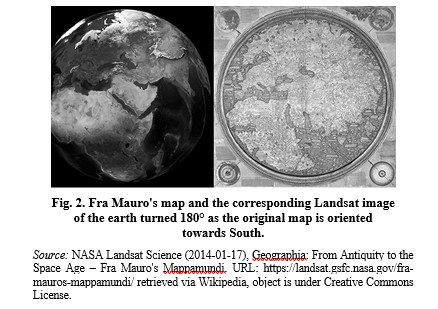
In the case of the Fra Maruo map (I have its reconstruction) the orientation of places in Western Europe and West Africa were checked by a ruler to measure the angles of the meridians with a line drawn from Lissabon to the Scilly Islands off the cape Land's End in Cornwall, from Istanbul (Constantinople) to the mouth of the River Danube by an angle meter and by Google Earth giving the orientation of such lines on a compass angle meter. I hoped to establish the assumed geographical North Pole of the Fra Mauro's map which was tilted when taking the straight line from the mouth of the River Indus. Fra Mauru drew a River Delta without the corresponding river to the Eastern shore of Madagascar which corresponds to what Fra Mauro identified as ‘Cab Diab.’ The NASA Landsat picture taking the Planet Earth from the assumed eye altitude of Fra Mauro suggested my doing so (Fig. 2).
The logics of my home-made analysis of Fra Mauro's map is shown below (in Fig. 3).
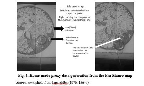
As it is shown in Fig. 3 the map reconstruction by Landström (1976: 186–7) was put on a small table oriented towards north with that compass-ruler, so that the orientation of any line between two points (in Fig. 3, right: the port of Soffala supposed to be at what may be Madagascar and a place named Goga in what should be the Indus delta, but is not since Mauro was confused about India. Suárez (1999: 48) thinks that Frà Mauro had access to the maps drawn by the Zhèng Hé naval expeditions (1405–33) which does not explain the possible confusion between the rivers Indus, Ganges and Irrawaddy or Mekong: according to Fra Mauro, Champa is on the Western side of the mouth of the River Ganges. It should be the Mekong. This error makes visible the incompatibility of Classical Greek Geography and the information available at Fra Mauro's time. This inconsistence should have culminated in the Asian Dragon Tail, an imagined subcontinent of Southeast Asia. It is shown on the famous Waldseemüller map, the first to indicate America (Suárez 1999: 90–129). On this map Madagascar is on the same meridian line as the mouth of the Indus as I have measured at the Landsat photo in Fig. 2 to establish the down tilt of the geographic North Pole. Whatever the NASA wanted to explain by that comparison, it is clear that Fra Mauro's map has multiple issues, but also explanations: The ‘legendae’ (i.e., comments) on the Fra Mauro map are edited by Falchetta (2006 and n.d.).
Concerning Cab Diab, supposed to be Madagascar, entry #48 has:
The ships or junks that sail this sea carry four masts. Beyond the decks they have cargo holds and 40 to 60 chambers for the travelers. The ships have only one stern rudder; being navigated without nautical compass, because they have an astrologer who, giving orders on the sailing directions from his high and separate position with his astrolabe in his hands (Author's translation).
followed by the famous mention of the discovery of the Cape of Good Hope by Asian navigators (Entry #19):
Around AD 1420 a ship or Indian junk sailed directly across the Indian Sea on its way to the islands of the Men and Women beyond the Cap Diab [i.e. Madagascar] situated between the green and dark islands in the direction of West-South-West to be sailed during 40 çornade [unit of time used aboard], finding nothing but air and water. The crew esteemed that they have already sailed 2000 miles when their supply started to run short, so they returned at “zorni #70) to the above-mentioned Cape (Falchetta n.d. Author's translation).
The point is that Fra Mauro's original term ‘bussolo’ means a compass for navigation. The ships of Zhèng Hé's fleet had compasses. Fra Mauro's entry is explicit about an ‘Indian’ junk sailing directly across the Indian Ocean heading for the so-called Cap Diab, but sailed too far in direction Southwest (‘Algabre’) to find the cape of Good Hope. But Malayan people did settle in Madagascar and obviously brought rice with them, which was likely the starter package for the African rice (Oryza glaberrima) (Kumar 2012).
4. DISCUSSION: ASPECTS OF VAVILOV WORLD-SYSTEMS
4.1. Vavilov centers and the El Niño ENSO phenomenon
Resilience is the ability of any system to cope with external turmoil or a tumultuous system environment. The seminal work by Davis (2001), which explained how the nineteenth-century European colonialism enforced the establishment of liberal market economy especially in India, depriving the indigenous socio-economic systems from their coping capacity with the impacts of the atmospheric phenomenon of El Niño Southern Oscillation (ENSO), helps to identify Vavilov centers whose resilience is imperative due to their geographic position in the impact area of ENSO.
Table 7
Centers, their assumed
pristine civilizations
and the ENSO impact area
|
# |
Assumed pristine civilization |
ENSO impact |
|
1 |
China: Xia, Shang and Zhou dynasty |
yes |
|
2 |
India: Indus valley civilizations |
yes |
|
2a |
South-East Asian civilizations |
yes |
|
3 |
Central Asia (Bactria) |
? no |
|
4 |
Anatolia: Hilly flanks of the Fertile Crescent |
no |
|
5 |
Mediterranean Center: Minoan civilization on Crete |
no |
|
6 |
Ethiopian center: Axum: Center in the highlands |
yes |
|
7 |
Southern Mexico: Mayas |
yes |
|
8 |
Andean Center: Altiplano |
yes |
|
8a |
none |
yes |
|
8b |
Brazilian-Paraguayan center: Assumed |
? yes |
The essentials are as follows: The domestication and evolution of major food crops started mainly in high mountain valleys, isolated from each other to a large extent and with considerable habitat diversity. Such selection regimes among the famous Andean cultivars (Cultivos Andinos) (NRC 1989) making the Andean region a role model for a Vavilov center. But there is a caveat: Neither ecological systems nor SES are closed systems in a thermodynamic equilibrium. Therefore, Burkhard, Fath and Müller (2011) published an article on ‘adapting the adaptive cycle’ of resilient ecological systems based on energy budgeting including potential work that can be performed by ecological systems (this kind of work is called emergy with m). They want resilience research to include well-known research on energy and culture (White 1943; Tainter 1990). We will discuss Diamond's Guns, Germs and Steel (Diamond 2004 [1997]) as a contribution to the issues of energy and cultural evolution later on.
4.2. Network Resilience, a Key to a General Theory?
Gotts (2007) pinpoints key variables of both, the model of a resilient system and the model of a World System. Whereas the a resilient system has panarchy as a system property, which is a set of metastable equilibria, the four-phase adaptive cycle is the key: It has the phases (1) exploration under the r-selector regime, for example, which means long-living complex plants, (3) Point Omega, either ossification under a gerontocracy regime or creative destruction. The example is the forest fire regime in fire-climax ecosystems to allow (4) release, which means emerging new life after the ‘revolution,’ the vector alpha indicating the new evolutionary pathway.
Resilience studies on World Systems are methodologically given way inter
alia by Barnes: Barnes et al. (2017)
emphasize network configuration as key to understand the resilience of
socio-ecologic systems (SES). In fact, the term network has here the subtext of
power configuration, so that adaptation to changing system contexts or system
transformation is indicated by ‘the adaptation–transformation gradient’ (Barnes et al. 2017: Figs. 1 and 3). This means changes in network configurations
and shifts in the patterns of their structural might (arché) (hierarchical, non-hierarchical, and heterarchical etc.). Bondarenko, Grinin, and Korotayev
(2002: 55) consider the specific regime and regime shift as a key to their
application of Vavilov's law of homogenous series as a tool for establishing
models on social evolution.
4.3. Mackinder's Approach to the Hegemonic Shift in World Systems
The hegemonic shift in World Systems (Grinin, Korotayev 2012; Wallerstein 2016) is promoted by China's One Belt, One Road (OBOR) project. On the political level, it should be China's alliance policy by what can be labelled as Silk Road paradigm (Plachetka 2015b: 31–38). The first to postulate a hegemonic shift in geopolitics was the British geographer Mackinder (1904): ‘Steam and the Suez Canal appeared to have increased the mobility of sea-power relatively to land-power’ in the mid-nineteenth century, when railways were just tributaries to the ports for seagoing ships. Transcontinental railroads are a game-changer (Mackinder 2004 [1904]: 311). Silk Road researchers such as Barisitz (2017a) refer to Mackinder. And we (Plachetka, Arraya 2015; Plachetka 2016) consider the congress of Vienna (1814–15) to have established a political World System. Europe's delayed ascent to World Hegemony (Frank 2008 [1998]) triggered a new set of rules for international relations. Frank explains that delay by a declining Kondratiev wave, (K-wave) whereas Europe and her Atlantic world enjoyed a rising wave. Barisitz's encyclopedic work on the terrestrial Silk Road (Barisitz 2017a) viz. its abridgement (Barisitz 2017b) confirms the importance of political hegemony over the terrestrial Silk Road Network to improve conductivity (Malkov 2014). Ptak (2007) considers the maritime Silk Road as more important than the terrestrial one. The objective of present China's re-establishment of the Silk Road is obviously the establishment of a World System communication channel for twisted networks of commodity exchange, capital (cheap credits), infrastructure connectivity and so-called people-to-people bonds (Pop 2016: 03). The seven voyages of Admiral Zhèng Hè (1405–1433) are now a re-actualized ‘historical capital’ for re-establishing the maritime Silk Road (Brewster 2018: 65).
4.4. Meritocracy in the Andean Highlands?
The striking parallel between maritime South-East Asia and the Inca Empire are networks of palaces with their urban agglomerations as hubs of trade viz. exchange networks. The Indonesian empires were thalassocracies asserting its hegemony over trade networks. Concerning our reconstruction of the Inca Empire (Plachetka, Pietsch 2009; Plachetka 2011) the Inca Empire may have been a meritocracy among rivalling noblemen who had to establish their leadership over other communities to turn them into their disciples, which is obvious in the case of Inca Yupanqui, who should become the Inca Yupanqui Pachacutek, the founder of the Inca Empire by defeating the rivalling Chanka polity and a coup d'état against the designated successor of Inca Viracocha, Urcon. John Earls (1976, 1989) developed a sophisticated model of Inca ecosystem control. It is plausible due to the impact of the foregone medieval climatic anomaly. This conception requires considering the Incas as experts in agricultural engineering. This expertise was a source of their power.
Recently, Alconini and Covey (2018) allow understanding that their publication is to set new standards on the Inca Empire. The question on how the Inca fed their people is investigated chiefly by Peruvian scholars. The issue of the real Inca system of governance (e.g., Rostworowski 1999) is a complicated one: Pärsinnen (2003) ventured a painstaking analysis on the political organization of the Inca Empire, indicating a complex system of multi-level government to be expected in the case of the law of homologous series in political evolution. In addition, there is a slight but important detail: Pedro Cieza de León, author of an important account on the Inca past, travelled across the conquered civilizations of South America between 1536 and 1551 eventually doing investigations for his Peruvian Chronicle (Crónica del Peru). He gives an overview of his report. Only the first volume, the geographical part, was published in Seville in 1553. There he says ‘In the second part I will write about the origins of the Incas Yupanquis, the former kings of Peru and their great achievements and government’ (Cieza 1973 [1553]: 18–19). Cieza is explicit on the Incas Yupanquis. Had there been other Incas as well? The traditional chronology of the Inca Empire (Rowe 1945: 277) has that Inca Pachacutek started to rule in 1438, the year he defeated the Chancas. Rostworowski (1999: 49–79) goes into details of the Chanca war and Inca Yupanqui Pachacutek's victory, anyway, there was no consensus about this event and the only account of a pre-Inca history is Book II of Fernando Montesinos' Ophir de España: Memorias antiguas historiales y politicas del Perú (Montesinos, Markham, Means 1920 [1644]); the entire account is mysterious (Gordon 2017) due to the disputed ‘Naples manuscripts’ an alleged trace of Blas Valera's lost Historia Occidenalis. The entire issue into an academic quicksand for scholars of Andean civilizations and an excellent material for the Andean version of Dan Brown's Da Vinci Code (Plachetka 2011: 89–98).
Paramount governmental reciprocity and redistribution (Rostworowski 1999: 68–79) based on regular delivery of goods across the Empire was technically impossible (see Tables 5.1–5.3), but politically imperative. It is a parallel to China's Zhèng Hé expeditions to establish or re-establish a system of governmental trade i.e. exchanging tributes to China with gifts by the Chinese court in return.
Earls (1976) explains Pachacuti's foundation of the Inca Empire as a state by technical improvements. A calendar reform and accompanying measures to foster governmental agriculture was done obviously in response to the end of the Medieval Climatic Anomaly. Plachetka (2011, 2014) has a concept of the Inca Empire based on regional competence centers of governmental maize agriculture housed in governmental palaces connected among each other by the Inca road system: There was not only a fleet of generosity similar to that commanded by Zhèng Hé, but imperial strongholds where prestigious goods were produced (D’Altroy 1992: 219). These strongholds had to be also supplied by regional producers. Therefore, D’Altroy provides figures concerning the production orbits, also known as ‘Von Thünen rings.’ The radius of the original Von Thünen rings indicates a law of diminishing returns by the costs of transport from the place of production to the market. Since the Inca Empire had no market economy here the kilocalories of the stored food for providing passing by caravans and specialists producing for the government minus the labor for production and transport to the imperial stronghold indicates such a radius.
The concept of governmental enclave economies may explain a similar phenomenon in Nusantara. The doctrine of the diminishing spirituality within the Cosmological State (Heine Geldern 1942) is to be questioned – the spirituality is concentrated at the sacred center, which means the king's Keraton. The Keraton, for example, at Yogyakarta has enclave economy, workshops to produce traditional batik cloths etc. The people at the periphery of such a state were considered as ‘less spiritual.’ Due to trade networks the Keraton was usually a hub of these networks whereas the rural orang kampungan were less spiritual hillbillies. The chief difference between the cosmological state and the Mandala System in Southeast Asia is that the Mandala System refers also to the diplomatic and commercial interaction systems among the cities (kota) either around a keraton or as entrepôt cities such as Surabaya within the entire cultural area of Southeast Asia. Anthony Reid employed the Annales-approach (Reid 1988; Wang 2012) to establish Southeast Asia as a cultural area viz. World System, but not a network analysis.
The Inca Empire should be portrayed not as a monolithic empire but a network Empire. The ecologic ‘archipelago’ model is the predominant way of organizing the cultivated landscapes in the Andean highlands (Murra 1996). These ‘islands of fertility’ are linked together by communication lines. It is relevant for the governmental agriculture.
Folk agriculture's momentum to propel the evolution of the Vavilov
center as far as we observed, lies with the specific topo-climatologic
conditions in the Puna zone (Earls 2006). Due to the low barometric pressure
and humidity deficit at altitudes above 3000 m.a.s.l. the atmosphere has hardly
any heat-retaining capacity responsible for extreme day-night amplitudes
especially in the dry season, when artificial irrigation is imperative. The
microclimatic conditions are shaped by humans using sensitive heat storages,
such as stones or soil bricks (surcos)
to manipulate the climate near the ground. The adverse impact of the reduced
heat-retaining capacity of the atmosphere at such altitudes are
thermodynamically determined fall-winds which must be prevented by terraces
with trees or bushes as wind brakes, as it was done in Taucar. Urpi's
statements describe the essentials for understanding the way by which the
terraced sinkholes of Moray should have worked.
4.5. Diamond's Contribution
In brief words, Diamond's theory concerns the development of complex societies or civilizations (Diamond 2004). Transferring Diamond's theory into a SES computer model was ventured by Lemmen (2000) and Wirtz, Lohmann, Bernhart and Lemmen (2010). The original model runs of the computer model developed by Lemmen (2000) produced virtual areas of pristine agriculture due to the quantification of Diamond's variables as proxy data. The production of non-existing Vavilov centers requires a local calibration viz. adaptation of the model. To me the energy input/product approach is too simple.
Note that in German the term Hochkultur (literarily ‘high culture’) is used for these types of SES. The conception of high cultures and their ‘altitude’ allows reducing Diamond's theory to the essentials: in the course of the Neolithic Revolution the energy density (edible kilocalories per mass unit) of crops increases. Multiplied with the numbers of crops under cultivation and their harvest in metric tons, the number of edible kilocalories at a civilization's disposal arises, so the SES becomes a ‘high culture.’ Once the process of gaining energy density is subject to the ‘law of diminishing returns’ (Tainter 1990) or comes to an end at all, the period of ‘qualitative growth’ is replaced by the period of quantitative growth characterized by the famous Malthusian trap. Therefore, the potential energy of the ‘Neolithic starter package’ which is to be transformed into ‘kinetic energy’ by the brain force of the Neolithic revolutionists determines the maximum ‘altitude’ of the respective ‘high culture.’ What is the technical counterpart of a system that transforms thermal energy (Kilocalories or Kilojoules) into altitude? It is the rocket. A rocket needs two kinds of propellants: The combustible and the oxidant. The total numbers of ‘combustibles,’ that is the plants and animals in the founder package of the Neolithic Revolutionists plus their potential marginal growth (in terms of edible kilocalories per kilogram) propelled by the process of cultivation by the employment of ‘brain force,’ the Neolithic sciences provides the pristine momentum for the respective SES to reach its peak altitude as a ‘high civilization.’
Especially a rocket-propelled plane as analyzed by Sänger (1933) who introduced the difference between thermodynamic and ballistic energy efficiency after the rocket engine's burn out makes these parallels plausible: the wings transform the rocket into a glider. The essential feature of rocket physics is the 2nd law of motion (action is reaction) but rockets (Sänger's ‘constant pressure rockets’) produce the same quantity thrust during their burning time. Despite of the constant thrust, the vehicle constantly accelerates. The reason for it is that the thrust has to move the entire mass of the vehicle (payload and fuel load) when starting but due to the loss of fuel load when flying under propulsion the total mass of the vehicle is diminishing. Therefore, the rocket accelerates. Korotayev (2005) argues that population growth goes along with a growth in the number of innovative people. He assumes a fixed percentage of innovative minded people of a given population. This means that the ‘brain force’ grows in absolute numbers with population growth in the course of the Neolithic Revolution. The creative people are considered here as the homologue to the oxygen of a rocket.
The viability of Vavilov centers depends also on geographical condition. In micro-climatically heterogeneous environments which are highlands especially with substantial solar radiation in Watts and reduced atmospheric heat-retaining capacity (lack of air humidity and reduced density of the atmosphere, both are heat storage media) seed adaptation to a specific regional climate (‘la quebrada’ which is an agriculturally used ravine in the Andes) is an imperative especially in the absence of bulk good trade.
Therefore, in Diamond's view the tilted axes of the continents are a determinant of the reachable ‘cultural altitude’ due to ecological belts depending on the geographical latitude (Turchin, Adams, and Hall 2006). Alas, this does not hold true for the ecological boundaries across the Malayan archipelago known as Wallace's and Huxley's Lines circumscribing pristine agroecological regions in the archipelago including Wallacea (shown for pig genetics by Larsen et al. 2007). The staple for humans in the Maluku archipelago is not rice but sago (metroxylon sagu) palm for staple food, which must be cooked and Banana (musa spp.), whereas the cash crop is nutmeg (myristica fragrans, pala). For the local domestic economy, we may imagine according to Diamond (2004) a gradient of ‘dwarfed local booster rockets of culture’ beyond the chief rice-producing centers. Their energy load depends on the agricultural potential of cultivable land on the Maluku islands, which eventually were completely depending on nutmeg and sandalwood trade.
Therefore, the big picture drawn by Diamond (Ibid.) is wrong: rockets that are burned out cannot be controlled unless they are rocket-planes and stay within the atmosphere. But the majority of Vavilov centers are constantly exposed to the turmoil caused by the ENSO events, so we may assume that in the absence of cultural hegemony of urban centers the Neolithic Revolution never ended.
4.6. The Lasagna Model of World Systems
La Lone (2000) defines the World System as a series of overlapping networks operating at specific levels of interaction like the pasta layers of the famous Italian Lasagna dish: the top layer is information exchange, below which is situated the layer of interaction is the exchange of highly valuable and prestigious goods such as silk (prestige good exchange), the bottom layer is bulk good exchange and the salsa, the meat sauce that keeps the layers together are cross network effects.
Concerning information exchange the Fra Mauro map clearly indicates the domain of systematic knowledge and the domain of narratives, that is less systematic knowledge. The systematic knowledge was produced by the expeditions of Henry the navigator. The expedition leaders were obliged to use the astrolabe and the compass (bussolo, hence the Spanish word brujola for orienteering compass, which is not derived from witch (bruja)) to draw portulans. Portulans are sea charts made by compass bearing. The narrative knowledge provided by Niccoló da Conti and other merchants, became systematized ex situ by scholars according to governmental and hence scientific epistemological standards. This frontier of the epistemological viz. information exchange level of a specific non-planetary world system is obvious on the Fra Mauro map. In such a context reducing Saskia Sassen's model of the global city (Sassen 2007) to its essentials means that the oligarchs of such a city (e.g., la signoria of Venice) prefer network interactions to other global cities, which corresponds to the South-East Asian mandala system. They are not typical states by anthropological definition, but polities fitting into their respective specific fitness region provided by the World System they are embedded in. The Mandala system is explicit in defining what is the center and what is the periphery seen from either a member state's center or from the broad perspective, the entire network and the rank of each polity within that network.
5. CONCLUSION
5.1. Variables for a Simple World System Energy Budget
The ‘Lasagne model’ of the World System (La Lone 2000; Chase-Dunn et al. 2010) defines a World System as a set of overlapping networks of information exchange, political and military interaction, prestige good exchange and bulk good exchange. Plachetka (2018) suggested the conception of the World System Interaction Volume (Q) and the respective interaction type's quota of the entire volume: If (i) most of a given Q is information, then it is an information-based World System. If (ii) most of a given Q is bulk good exchange it is a commodity-based World System. If (iii) most of a given Q is prestige-good exchange or luxury such as the Silk Road we may talk about an elitist World System.
This conception corresponds to the following evidences:
i. Crop exchange in the Andean Vavilov center is of course information exchange. The relevant information is the specific germplasm's DNA while this interaction level is embedded by ‘ecologic exogamy.’
ii. Before the advent of railroads, the bulk good transport was extremely expensive and therefore restricted to navigation. No matter, whether it was deep-sea navigation or inland waterway navigation.
iii. So-called prestige goods interaction is a complex issue, portrayed by the Fra Mauro Map. It has the form of a portolano based on the results of the Portuguese expeditions which Henry the Navigator had launched at the African West coast and the non-specific narratives from Asia that reached Venice by itinerant merchants such as Niccolò da Conti.
Jenkins (2001) made explicit the mathematical essentials of the Inca roads and hence the Inca World System by Graph theory. A graph is the sum of nodes (railway stations. road posts etc.) of different centrality linked together by lattices to form a network. Malkov (2014) elaborated friction as a criterion for the non-feasibility of a specific way for travel or transport. To overcome friction energy is required. Therefore, the required dimensions are (1) length, (2) mass, (3) time, (4) frequency, and (5) a possible transformation of proxy data into energy.
1. Length refers to non-geodetic lines according to graph theory.
2. Mass: Due to the equivalence of thermodynamic energy and technical work. For work the dimension mass (m) is to be added to length: Work (w) = force*s. Since force is needed to move mass, it is equivalent to m*s. S is way (spatium) which means the length of the graph. Energy (E) is measured in Joules. E = (m*v^2)/2.
3. Time refers to the vegetation period in the Inca Empire. Travel duration matters, as time determines also the requirement of energy which means food and feed supplies to be carried for a caravan travelling from one road post (‘filling station’) to another, the local availability of supply at each filling station and the locally specific ecologic vegetation period (PD period days: fixed in seed calendars for agriculture).
4. Frequency. This dimension became visible thanks to Bauer's (1996) methodology to identify the pre-imperial Inca state by measuring the percentage of Inca ceramics (of the Killke pottery style) of the total amount of ceramics excavated at places where so-called Incas by privilege dwelled producing their specific ceramic styles. The presence of the Killke pottery and its local stratigraphy indicates interaction events between Cusco, the Inca capital and the regional groups, to be measured by a gradient of interaction. The units for the x-Axis are the length of the ways to them and the y-Axis is the percentage of the Inca ceramics. The gradient is a plotted graph on that chart which indicates the interaction frequency in dependence to the distance. The frequency of diplomatic interaction manifested by political reports from the Austrian embassy in Brazil to Vienna in the case of nineteenth-century Paraguay helped us to trace the impact of the hegemonic shift of the World System (Plachetka, Arraya 2015).
5. The at item (2) mentioned equivalent of thermodynamic energy (vintage unit Kilocalories) and mechanical work (vintage unit Kilogram-force meters) means that 427 kilogram-force meters are 1 Kilocalorie (Sänger 1933: 16), that is 4.184 Kilojoules.
The available food is limited by the Net Primary Production, which is the increase in an ecosystem's biomass during a vegetation period. This issue of food and feed available at the equivalents of filling stations makes caravan networks vulnerable to climate turmoil or climate change. Therefore, the World System interaction volume is limited by the budget of potential technical energy per interaction level. It is the distance and energy balance that makes plausible the recently disputed the El Alcaya report on Samaipata as a maize growing center. Samaipata is situated at the maximum range of military agency of the Incas. An installation of terraced sinkholes similar to Moray still in use for maize was identified in the Collca valley (Plachetka 2011: 159–161), which is populated by resettles for frontier agriculture. There are local indigenous sorts of maize (zea mays).
The original concept of China's New Silk Road seems as if it was intended to apply the ‘lasagna’ model of the World System research:
Table 8
The
parallels between the so-called New Silk Road
and
the World System approach
|
China's present concept (Pop 2016) |
Show case |
Historical references |
|
Political Coordination |
Zhèng Hé in Indonesia |
|
|
Technical coherence of infrastructure |
Cultural brokers (Chinese sojourners) |
Reid, Alilunas-Rodgers (1996) |
|
Conductivity of trade routes |
Perhaps the reason to foster the Islam made in China |
Kong (2015) |
|
Financial integration |
Silver standard |
Frank (2008 [1998]) |
|
People-to-People bonds |
From Peru: the ecologic exogamy |
|
The development of indigenous money system (Wicks 1992) in Southeast Asia suggests that the governmental coffers were filled by durable grains that can be stored: rice (oryza sativa) and maize (zea mays). Storable crops were required to finance the most important component for state formation: officials and bureaucrats (Grinin 2012: 63–135). The next vague concept is that of a city according to Yoffee (2009); however, Sassen's definition of a global city reduced to its essentials as a network hub is a common denominator of urban agglomerations in both Maritime South-East Asia and the Andean civilization at least during Inca rule.
5.2. Some Suggested Distinctive Traits of a Vavilov Culture
1. Vavilov cultures are geographically situated in highlands between 45°N and the tropics of Capricorn in the Old World and the American tropics in the New World. Mountain areas are a microclimatic mosaic so that gene-flow between distinctive habitats is possible (habitat diversity per square grid). Seeds from the Urnfield culture excavated at the river March northeast of the city of Vienna provided evidence that the Urnfield people's seed were in fact representatives of an archaic stage of crop evolution when compared to the Middle Eastern Vavilov center (Plachetka, Pietsch 2009). Crop evolution did not happen beyond 45°N. In Peru this was explained by fuzzy microclimatic spots due to the solar radiation regime on such high latitudes.
2. The principles of reciprocity manifested by seed exchange reminds on the information exchange level of the World System, but comes to an end at ecological barriers beyond which the original seeds from the pristine center become useless.
3. The sage kings in China, Indonesia and the Inca Empire may were held responsible for ecologic and social welfare. Since the Neolithic scientists did no publish scientific papers, their findings were transmitted by rituals and religious belief systems. Such an epistemology justifies the necessity of a sage-king or sacred king, but the evidences for that feature we found in Peru only. Therefore, the theory by Conrad and Demarest (1984) on ideology which also integrates knowledge systems, deserves a reconsideration in the context of Vavilov cultures.
4. The concept of cities is in need of a revision (Yoffee 2009) as they may depend on trade hubs.
In short, similar enabling and restraining conditions produce similar results of local social developments. The idea of a master sequence of social development is therefore to be dismissed.
REFERENCES
Acharya, A. 2011. The Making of South-East Asia. Ithaca: Cornell University Press.
Alconini, S., Covey, A. (eds.) 2018. The Oxford Handbook of the Incas. Oxford: Oxford University Press.
Altieri, M., Merrick, L. C. 1987. In situ Conservation of Crop Genetic Resources through Maintenance of Traditional Farming Systems. Economic Botany 41 (1): 86–96.
Barisitz, St. 2017a. Central Asia and the Silk Road. Economic Rise and Decline over Several Millennia. Heidelberg – New York: Springer.
Barisitz, St. 2017b. Aufstieg und Niedergang der Seidenstraße über zwei Jahrtausende. Ein kurzer Überblick. Zeitschrift für Weltgeschichte 18 (2): 27–42.
Barnes, M. L., Bodin, Ö., Guerrero, A. M., McAllister, R. J., Alexander, S. M., and Robins, G. 2017. The Social Structural Foundations of Adaptation and Transformation in Social-Ecological Systems. Ecology and Society 22 (4): 16. URL: https://doi.org/10.5751/ES-09769-220416. Accessed December 14th, 2018.
Barthélemy, M. 2011. Spatial Networks. Physics Reports 499 (1–3): 1–101.
Bauer, B. S. 1996. El desarollo del estado Inca (Estudios y debates regionales andinos 96). Cusco: Centro Andino Bartolomé de las Casas.
Bauer, B. S. 2008. Cusco antiguo, tierra natal de los Incas. (Archivo de Historia Andia 43). Cusco: Centro Andino Bartolomé de las Casas.
Behringer, W. 2009. A Cultural History of Climate. London: Polity Press.
Bellwood, P. 1992. Southeast Asia before History. In Tarling, N. (ed.), The Cambridge History of Southeast Asia I: From Early Times to 1800. Vol 1 (pp. 55–136). Cambridge.
Bondarenko, D. M., Grinin, L. E., and Korotayev, A. V. 2002. Alternative Pathways of Social Evolution. Social Evolution and History 1 (1): 54–79.
Brinken, A. D. von den. 1968. Mappa Mundi und Chronographie. Studien zur Imago Mundi des abendländischen Mittelalters. Deutsches Archiv zur Erforschung des Mittelalters 24: 168–186.
Brewster, D. 2018. The MSRI and the Evolving Naval Balance in the Indian Ocean. In Blanchard, J.-M. F. (ed.), China's Maritime Road Initiative and South Asia (pp. 55–80). Singapore.
Bronham, L., Penny, D. 2003. The Modern Molecular Clock. Nature Reviews: Genetics 4: 216–224.
Brush, St. B. 2004. Farmer's Bounty. Locating Crop Diversity in the Contemporary World. New Haven and London: Yale University Press.
Buckley, B. M., Anchuatis, K. J. et al. 2010. Climate as a Contributing Factor in the Demise of Angkor. Cambodia. Proceedings of the National Academy of Science (PNAS) 107 (15): 6748–6752.
Burkhard, B., Fath, B. D., Müller, F. 2011. Adapting the Adaptive Cycle: Hypothesis on the Development of Ecosystem Properties and Services. Ecological Modelling 222: 2878–2890.
Cattaneo, A. 2011. Fra Mauro's Mappamundi and Fifteenth-Century Venetian culture (Terrarum Orbis 8). Turnhout: Brepols.
Chase-Dunn, Chr., Niemayer, R.-Alvarez, A., Inoue. I., Lawrence. K., Love. J. 2010. Cycles of Rise and Fall. Upsweeps and Collapses. Changes in the Scale of Settlements and Polities since the Bronze Age. In Grinin, L., Herrmann, P., Korotayev, A., Tausch, A. (eds.), History and Mathematics. Processes and Models of Global Dynamics (pp. 64–91). Volgograd: Uchitel.
Childe, G. 2002 [1942].¿Qué sucedió en la historia? (Biblioteca del Bosillo 83). Barcelona. orig. What happened in history? London.
Cieza de León, P. 1973 [1553]. La crónica del Perú (Biblioteca Peruana 1). Lima.
Coèdes, G. 1968. The Indianized States of Southeast Asia. Honolulu.
Conrad, G. W., Demarest, A. 1984. Religion and Empire. The Dynamics of Aztec and Inca Expansionism. Cambridge: Cambridge University Press.
D’Altroy, T. N. 1992 Provincial Power in the Inca Empire. Washington-London: Smithonian Institution
Da Conti, N. 1841. Relazione. In Carrei, L. (ed.), Relazioni di Viaggiatori. Bd. 1 (pp. 235–277). Venezia.
Davis, M. 2001. Late Victorian Holocausts. El Niño famines and the Making of the Third World. London: Verso.
Day, T. 2002. Fluid Iron. State Formation in South-East Asia. Honolulu: University of Hawai’i Press.
Diamond, J. 2004 [1997]. Armas, Gérmenes y Acero. Breve historia de la humanidad en los últimos trece mil años. Barcelona: Debate (original: Guns, Germs, and Steel: The Fates of Human Societies).
Earls, J. 1976. Evolución de la administración ecologica inca. Revista de Museo Naciónal 42: 207–245.
Earls, J. 1989. Planificación Agricola andina. Bases para un manejo cibernético de sistemas de andenes. Lima: COFIDE y Universidad del Pacifico. [In Spanish].
Earls J. 2006. Topoclimatologica de Alta Montaña. Lima: CONCYTEC.
Falchetta, P. 2006. Fra Mauro’s World Map (Terrarum Orbis 5). Tournhout: Brepols.
Falchetta, P. N.d. Trascricione integrale delle iscrizioni del Mappamondo di Fra Mauro conservato presso la Biblioteca Marciana di Venezia online. URL: http://geoweb.venezia.sbn.it/cms/images/stories/Testi_HSL/FM_iscr.pdf. Accessed Nov. 12th, 2018.
Frank, A. G. 2008 [1998]. ReOrient. Globalwirtschaft im asiatischen Zeitalter. Wien: Promedia.
Conrad, G.W., Demarest, A. 1984 Religion and Empire. Cambridge: Cambridge University Press.
Gordon, N. J. 2017. Ophir de España and Fernando de Montesino's Divine Defense of the Spanish Colonial Empire: A Mysterious Ancestral Merging of pre-Inca and Christian Histories. University Thesis, University of Colorado at Boulder.
Graham, N. E., Ammann, C. M., Fleitmann, D., Cobb, K. M., Luterbacher, J. 2011. Support for Global Climate reorganization during the ‘Medieval Climatic Anomaly.’ Climate Dynamics 37: 1217–1245.
Grinin, L. 2012. Macrohistory and Globalization. Volgograd: Uchitel.
Grinin, L., Korotayev, A. 2012. Does ‘Arab Spring’ Mean the Beginning of World System Reconfiguration? World Futures 68 (7): 471–505.
Gotts, N. 2007. Resilience, Panarchy, and World-Systems Analysis. Ecology and Society 12 (1). URL: http://www.jstor.org/stable/26267856. Accessed Dec 14th, 2018.
Guaman Poma de Ayala, F. (ed.) 1987 [1615]. J. V. Murra. R.
Adorno.
J. Uriotse: Nueva Crónica y buen
gobierno (Crónicas de América 29) 3 vols. Madrid: Historia 16.
Hall, K. R. 2016. Commodity Flows. Diaspora Networking. and Contested Agency in the Eastern Indian Ocean (c. 1000–1500). TRaNS: Trans-Regional and -National Studies of Southeast Asia 4 (2): 387–417.
Harlan, J. R. 1971. Agricultural Origins: Centers and Non-Centers. Science 174 (4008): 468–474.
Hawkes, J. G. 1997. Back to Vavilov: Why were Plants Domesticated in Some Regions and not in Others? In Damania, A. B., Valkoun, J., Willcox, G., Qualset, C. O. (eds.), The Origins of Agriculture and Crop Domestication. Harlan Symposium, Aleppo 10–14. March 1997. URL: https://www.bioversityinternational.org/fileadmin/bioversity/publications/Web_version/47/begin.htm#C... Accessed September 6th, 2018.
Heine Geldern, R. 1942. Conceptions of State and Kingship in Southeast Asia. The Journal of Asian Studies 2 (1): 15–30.
Ho, S. Y. W. 2014. The Changing Face of the Molecular Evolutionary Clock. Trends in Ecology and Evolution 29 (9): 496–503.
Homberger, E., Homberger, N. 2013. Diccionario Trilingue Quechua de Cusco: Qwiswa, English, Castellano (Monumenta Lingüistica Andina 10). Cusco: Centro Andino Bartolomé de las Casas.
Horridge, A. 2015. Perahu Laya Tradisional Nusantara. Yogyakarta. [in Bahasa Indonesia]
Hurtado Fuertes, C. 2000. La alimentación en el Tahuantinsuyo. Lima.
Jenkins, D. 2001. A Network Analysis of Inka Roads. Administrative Centers and Storage Facilities. Ethnohistory 48 (4): 655–687.
Khoury, C. K., Achicanoy, H. A. et 14 al. 2016. Origins of Food Crops Connect Countries Worldwide. Proceedings of the Royal Society B: Biological Sciences 283 (1832) URL: http://rspb.royalsocietypublishing.org/content/283/1832/20160792#ref-20. Accessed Nov. 1, 2018.
Kong, Yuanzhi. 2015 [2000]. Cheng Ho. Muslim Tionghoa. Misteri Perjaanan Muhibah di Nusantara. Jakarta (3rd updated edition 2015). [in Bahasa Indonesia]
Korotayev, A. 2005. A Compact Macromodel of World System Evolution. Journal of World-System Research 9 (1): 79–93.
Korotayev, A., Zinkina, J., Kobzeva, S., Bozhevolnov, J., Khaltourina, D., Mal-kov, A., Malkov, S. 2011. A Trap at the Escape from the Trap? Demographic-Structural Factors of Political Instability in Modern Africa and West Asia. Cliodynamics 2: 276–303.
Kumar, A. 2012. Domination over Palm and Pine. Early Indonesia's Maritime Reach. In Wade, G., Tana, L. (eds.), Anthony Reid and the Study of the Southeast Asian Past (pp. 101–122). Singapore.
Kurella, D., and del Castro, I. (ed.) 2013. Inka – Könige der Anden. Stuttgart – München: Lokschuppen.
Landström, B. 1976. Buch der frühen Entdeckungsreisen in Farbe, Gütersloh.
La Lone, D. 2000. Rise, Fall, and Semi-Peripheral Development in the Andean World System. Journal of World System Research 6 (1): 67–98.
Larsen, G. et. 31 al. 2007. Phylogeny and Ancient DNA of Sus Provides insights into Neolithic Expansion in Island Southeast Asia and Oceania PNAS 104 (12): 4834–4839. URL: https://doi.org/10.1073/pnas.0607753104. Accessed Dec. 14th, 2018.
Legge, J. D. 1992. The Writing of South-East Asian History. In Tarling, N. (ed.), The Cambridge History of Southeast Asia I: From Early Times to 1800 (pp. 1–50). Cambridge.
Lemmen, C. 2000. Understanding the Regional Rise of Civilization by Means of a Model with Effective Variables. Working Group System Analysis and Modelling, Carl von Ossietzky University, Oldenburg – Germany.
Lieberman, V. 2009. Strange Parallels. Southeast Asia in Global Context. Vol 2. Mainland Mirrors: Europe, Japan, China, South Asia and the Islands. Cambridge: Cambridge University Press.
Ma Huan. 1970 [1433]. Ying-yai Sheng-lan. The Overall Survey of the Ocean's Shores. Hakluty Society Extra Series. Cambridge.
Mackinder, J. H. 2004 [1904]. The Geographical Pivot of History. The Geographical Journal 23 (4). re-issued ibd. 170 (4): 298–321.
Malkov, A. 2014. The Silk Roads. A Mathematical Model. Cliodynamics 5: 4–22.
Montesinos, F. De, Markham, C. R., Means, Ph. A. 1920 [1644]. Memorias antiguas historiales del Peru (The Hakluyt Society II, 48). London.
Morlon, P. (ed.) 1996. Comprender la agricultura campesina en los Andes Centrales Peru-Bolivia. Lima: Instituto Francés de Estudios Andinos y Centro Bartolomé de las Casas.
Murra, J. V. 1975. Formaciónes económicas y politicas del mundo andino (Instituto de Estudios Peruanos: Historia Andia 3). Lima.
Murra, J. V. 1996. Quince años después: Balance de la noción del archi-pelago. In Morlon, P. (ed.), Comprender la agricultura campesina en los Andes Centrales Peru-Bolivia (pp. 130–135). Lima: Instituto Francés de Estudios Andinos y Centro Bartolomé de las Casas.
Murra, J. V. 2008 [1972]. El control vertical de un máximo de pisos eco-lógicos en la economia andina. In Arauco Camacho, H. G. (ed.), Los Andes y las poblaciónes andinas en la agenda de la regionalización y descentralización. 2 vols. Vol.1 (pp. 27–49). Lima: CONCYTEC.
NRC=National Research Council. 1989. Lost Crops of the Incas. Little-Known Plants of the Andes with Promise for Worldwide Cultivation. Washington. DC: The National Academies Press.
Panji, T. 2015. Kitab sejarah terlengkap Majapahit. Jogjakarta: Laksamana. [in Bahasa Indonesia]
Pärsinnen, M. 2003. Tawantinsuyu. El estado inca y su organización política (Travaux de l’Institut Francais de études Andins 153). Lima.
Plachetka, U. Chr. 2011. Die Inka. das Imperium. das aus der Kälte kam. Frankfurt am Main-New York etc.: Peter Lang.
Plachetka, U. Chr. 2014. Sundials for Urban Farming in an Early Inca City. Universal Journal of Agricultural Research 2: 107–114.
Plachetka, U. Chr. 2015a. The Significance of Andean Terraces for Indigenous Knowledge on Agro-Ecology: The Moray Puzzle (refined version). URL: https://www.academia.edu/11746513/The_significance_of_Andean_terraces_for_indigenous_knowledge_on_agro-ecology_The_Moray_puzzle_refined_version. Accessed Dec. 12, 2018.
Plachetka, U. Chr. 2015b. Angry Eagle versus Kung-Fu Panda: Geopolitics by Nuclear Power Plants? Der KonaK 18: 30–39. URL: https://www.aca-demia.edu/26344325/Angry_Eagle_versus_Kung_Fu_Panda_On_the_New_Silk_Road. Accessed Dec. 11th 2018.
Plachetka, U. Chr. 2016. Paraguay Facing the Abrupt World System Reconfiguration established by the Congress of Vienna. International Sociological Association Economy & Society December 2016: 6–8.
Plachetka, U. Chr. 2018. Energy, Resilience and the Chinese World-System. International Sociological Association Economy & Society June 2018: 18–20.
Plachetka, U. Chr., Pietsch, St. A. 2009. El Centro Vaviloviano en el Perú. Un conjunto socio-ecológico frente a riesgos extremos. Tikpa Pachapaq 1 (1): 9–16.
Plachetka, U. Chr., Muñoz Villar, L. H. 2009. Peru – Cultura Vaviloviana? Un ejemplo para el ‘experimento histórico; según Jared Diamond. Tikpa Pachapaq 1 (1): 18–21.
Plachetka, U. Chr., Arraya. L. 2015. Suzeränität als Folge des Wiener Kongresses. Zeitschrift für Weltgeschichte 16 (2): 137–54.
Polo de Ondegardo, J. 2013. Chirinos, A., Zegarra, M. (eds.). El orden del Inka. Lima: Editorial Comentarios.
Pop, I. I. 2016. Strengths and Challenges of China's One Belt One Road initiative. London: Centre for Geopolitics & Security in Realism Studies.
Ptak, R. 2007. Die maritime Seidenstrasse. Küstenräume. Seefahrt und Handel in vorkolonialer Zeit (South China and Maritime India 4). Wiesbaden.
Pulgar Vidal, J. 1996. Geográfia del Perú. Los ocho regiones naturales. la regionalización transversal. La sabidura ecológica tradiciónal. 10th edition. Lima: PEISA.
Ratzel, F. 1882–1891. Anthropogeographie. Vol 1, Stuttgart, Vol 2. München: Oldenburg.
Reid, A. 1988. South-East Asia in the Age of Commerce 1450–1680. Bd. 1: The Lands below the Wind. New Haven – London.
Reid, A. 2000. Charting the Shape of Early Modern South-East Asia. Chiang-Mai. Singapore.
Reid, A., Alilunas-Rodgers, K. (eds.) 1996. Sojourners and Settlers. Histories of South-East Asia and the Chinese. St. Leonardi – Australia.
Rostworowski de Diez Canseco, M. 1999. Historia del Tawantinsuyu (Historia Andina 13). 2nd extended edition. Lima: Instituto de Estudios Peruanos and Prom Peru.
Ribeiro, D. 1992. Las Américas y la civilización. Proceso de formación y causas del desarollo desigual de los pueblos américanos (Biblioteca Ayacucho 120), Caracas-Venezuela.
Rowe, J. H. 1945. Absolute Chronology in the Andean areas. American Antiquity 10 (3): 265–284.
Sänger, E. 1933. Raketenflugtechnik. München-Berlin: Oldenburg.
Sassen, S. 2007. Una sociología de globalisación. Análisis Politico 61: 3–7. Bogota.
Schmidt, M., Wei, W. 2006. Loss of Agro‐Biodiversity. Uncertainty. and Perceived Control: A Comparative Risk Perception Study in Austria and China. Risk Analysis 26 (2): 455–470.
Suárez, Th. 1999. Early Mapping of Southeast Asia. The Epic Story of Seafarers. Adventures and Cartographers who first mapped the regions between China and India. Singapore. Hong Kong. Indonesia: Periplus Editions.
Tainter, J. 1990. The Collapse of Complex Societies. Cambridge: Cambridge University Press.
Trouet, V., Esper, J., Graham, N. E., Baker, A., Scourse, J. D., Frank, D. C. 2009. Persistent Positive North Atlantic Oscillation Mode Dominated the Medieval Climate Anomaly. Science 324 (5923): 78–80.
Turchin, P., Adams, J. M., Hall, Th. D. 2006. East-West Orientation of Historical Empires and Modern States. Journal of World-Systems Research 12 (2): 219–229. URL: https://jwsr.pitt.edu/ojs/index.php/jwsr/article/view/369. Accessed Dec 14th, 2018.
Vavilov N. I. 1922. The Law of Homogenous Series in Variation. Journal of Genetics 12 (1): 47–91.
Vavilov, N. I. 1951. Estudios sobre el origen de las Plantas Cultivadas. Buenos Aires: ACME. [in Spanish]
Vavilov, N. I. 2004 [1931]. El problema del orígen de la agricultura mundial a la luz de las últimas investigaciones. El Catobeblepas 32 (4). 17 URL: http://nodulo.org/ec/2004/n032p17.htm. Accessed Sept. 8th. 2018.
Wade, G. 2012. Southeast Asian Islam and Southern China in the Fourteen Century. In Wade, G., and Tana, L. (eds.), Anthony Reid and the Study of the Southeast Asian Past (pp. 125–146). Singapore: Institute of Southeast Asian Studies.
Wallerstein, I. 2016. The U.S. Election: It's over at last. Or is it? International Sociological Association RC 02: Economy and Society, December: 4–5.
Wang, G. 2012. A Two-Ocean Mediterranean. In Wade, G. and Tana, L. (eds.), Anthony Reid and the Study of the Southeast Asian Past (pp. 68–84). Singapore: Institute of Southeast Asian Studies.
White, L. 1943. Energy and the Evolution of Culture. American Anthropologist 3 (1): 335–356.
Wicks, R. 1992. Money. Markets and Trade in Early Southeast Asia: The Development of Indigenous Monetary System to AD 1400. Ithaca.
Wright, K., Wright, R., Valencia Zegarra, A., and McEvan. G. 2011. Moray: Inca Engineering Mystery. Reston: ASCEE Press.
Wirtz, K., Lohmann, G., Bernhardt, K., Lemmen, C. 2010. Mid-Holocene Regional Reorganization of Climate Variability. Analysis of Proxy Data in the Frequency Domain. Palaeogeography 298 (3–4): 189–200.
Wisseman-Christie, J. 1986. Negara, Mandala and Despotic State. In Marr, D. G., Crothers, Milner, A. (eds.), South-East Asia from the 9th to the 14th century (pp. 65–86). Singapore.
Yoffee, N. 2009. Making Ancient Cities Plausible. Annual Review of Anthropology 38 (4): 264–289.
Zinkina, J., Ilyin, I., and Korotayev, A. 2017. The Early Stages of Globalization Evolution: Networks of Diffusion and Exchange of Domesticates. Technologies, and Luxury Goods. Social Evolution & History 16 (1): 69–85.
Размещено в разделах